
from Ras Alayn to Aleppo. The travellers took quite
an indirect route from Rakka to Aleppo and there
is the clearest mention of archeological investigations
conducted during 3 days at Kaletül Cebir (Cebir Kalesi).//
In 1872 England had its eye on the Euphrates valley
for a railway to the Persian Gulf from Turkey. See this
TNT report for the details and the entire British
report: Britain's Euphrates Valley Rail Dream //

This map, included in the travel log, shows
the second half of the trip from Ras Alayn to
Aleppo. Rakka and environs are at lower
right. At the top-center of the map are Halfeti
and Rumkale. The left side shows Antep, and
then down to Aleppo.
From the Euphrates to Aleppo:
At 5:30 o'clock we set out to the west and 15 minutes later, following
the river bed again, we proceeded for another two hours. Our
direction was mostly west-southwest. On the right was a line of hills
and we could see Telüebis from here. There was no trace of human
life anywhere around, only a few tents on the banks of the Euphrates.
A bit later, we encountered the Rakka-Meskene road, which alternately
followed the hills and the river bank. An hour later we saw Kaletül
Cebri to the northwest.
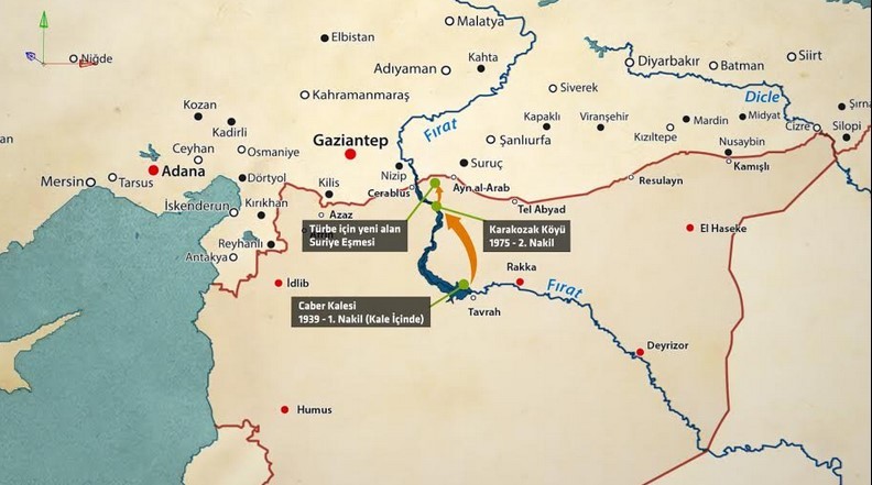
Caber Kalesi (Kaletül Cebri) was the sight of the tomb of
Süleyman Shah, the grandfather of Ottoman founder Sultan
Osman. In 1921 the land there became Turkish sovereign
territory. In 1975 the tomb was moved further north and,
again in 2014, closer to Turkey because of threats from ISIS.
At 1:10 o'clock we pitched our tents just outside the city. After spending
3 days here to carefully examine the ancient monuments, on the
morning of 13 April at 5:15 o'clock we headed out on the caravan road,
along which we encountered Bedouin tents between the road and the
city. At 9:15 o'clock, we came to the place where the Euphrates bends
like an elbow and got caught in a sand storm, which increased in
ferocity over the next two hours, making it very difficult for us to fix
our direction.
At 9:15 o'clock, we headed northwest and at 10:40 o'clock we left the
road near Meskene and pitched our tents. The next day, we had to set
out at 7 o'clock because of the matter of changing the Gendarmerie
guards. For about an hour we headed east, found the caravan road
and went north in order to descend into the Euphrates valley. But then
a fierce storm broke out and we lost our way, moving forward only
with great difficulty.
At about 2 o'clock we encountered some tentdweller Bedouins. And
although we weren't able to find any feed for the animals here, we
decided to make camp since we couldn't really see where we were
going. At 6 o'clock on the morning of 15 April, the muleteers loaded
the animals and showed us the way to the caravan road, saying that
if we headed north for 20 minutes we would come to it.
On the right about a kilometer away we could see Cebel-i Gleb. In
front of us there were a number of lines of big hills extending beyond.
At 7:30 o'clock, we passed through a deep gorge and at 8:40 o'clock
we entered the Euphrates vally and saw cultivated fields and tents here
and there. From here the road went north-northwest for hours. Firstly,
we passed two hills and came to a area of clean sand and then Telül
Mesudiye, where the Euphrates's elbow is located, entering into land
made up of a dry river bed and hills.
From here we continued north, following the crest-line of the hills,
seeing the forts of Serrin along the way. Our caravan continued on
without stopping toward Serrin and at 3:55 o'clock we arrived at the
village of Serrin, which is surrounded on three sides by hills and built
on the northeast side of this location.
On 16 April at 0:25 o'clock it began to rain and continued for hours.
We pressed on to the northwest and in 65 minutes we passed a
mountain, at 8 o'clock a river and then 45 minutes later we arrived at
a Türkmen village named Hors. Because of the bad weather, we stayed
here for two hours. The villagers told us that we would encounter many
Kurdish villages to the west. So we headed from the Euphrates in that
direction and at 12:45 o'clock we passed through a summer pasture with
cultivated fields and villages. At 1 o'clock we came to the juncture of
the Urfa-Zeruk-Aleppo roads at Kazmiye.
At 1:45 o'clock we stopped at Ilıcak village, which is situated on the
bank of a rather large stream, from which the fields are irrigated. The
next day, we headed north-northwest and reached the outskirts of
Daylıka village in an hour and 15 minutes. Here we passed through
cultivated fields, which opened into a high summer pasture.

Birecik is at bottom-left center. Halfeti and Rumkale are a bit
to the north along the Euphrates.
At 10:10 o'clock, we entered a vast desert and a bit later we saw a
village on the right bank of a stream. Twenty minutes after passing
two mills and the stony and dry stream, we re-entered the Euphrates
valley. From here to Birecik the road was very good. When we came
to Birecik we stayed in an inn for two days. The animals were able
to rest a bit.
On the 20th of April at 6 o'clock in the morning, we headed north
along the Euphrates, where the rocks are quite close to the river. At
the place where the river makes an elbow, we turned from the
mountainous area and began to see cultivated and fertile land. At
1:05 o'clock, we again entered a mountainous area with beautiful
gardens and prosperous villages.
Toward 12 o'clock we went up a steep path and entered into a orchard
on the river bank and 45 minutes later we arrived at Halfeti. We
stayed here for an hour and a half to have the animals shod. Although
we were able to find a raft at Halfeti, since there wasn't a road north
on the other side of the river we couldn't use it.
As we continued on, we lost sight of the Euphrates twice because
we were walking amid hills. At 2:45 o'clock we could see Rumkale on
the left bank of the Eurphrates and 10 minutes later we passed by raft
to Balazir village and in another 15 minutes we arrived at Rumkale,
from where I wanted to go to Antep. So, first we had to enter a
summer pasture and follow a steep path forward for about 35 minutes.
Consequently, by following this way at 10:20 o'clock we headed
west-northwest along the Karababa hills and came to the Merziman
stream that emties into the Euphrates at Rumkale. At 1:30 o'clock,
proceeding to the north-northwest and following the Arki stream,
we stayed at a Turkish village named Hami Marla for a day.

From (Gazi)Antep to Aleppo.
The next day, after passing southwest through a broad and rocky area
for 3 hours, at 9 o'clock we reached hill from where we could see
Nemrud Mountain. The road headed toward Marbut and by following
a stream bank the whole way we came to Sevvas. Here we crossed
over a stone bridge to the other bank, continuing southwest over
mountains and streams, arriving at Antep by crossing over a bridge
at Saçur. The road from Antep to Aleppo was ver good. Along the
way we visited one village after another in the course of a day. Then,
heading south and passing through villages on stilts we arrived at
Aleppo.
Date 5 January 1914
Y.R. (Yusuf Rıza)
We pressed on to the northwest and in 65 minutes we passed a
mountain, at 8 o'clock a river and then 45 minutes later we arrived at
a Türkmen village named Hors. Because of the bad weather, we stayed
here for two hours. The villagers told us that we would encounter many
Kurdish villages to the west. So we headed from the Euphrates in that
direction and at 12:45 o'clock we passed through a summer pasture with
cultivated fields and villages. At 1 o'clock we came to the juncture of
the Urfa-Zeruk-Aleppo roads at Kazmiye.
At 1:45 o'clock we stopped at Ilıcak village, which is situated on the
bank of a rather large stream, from which the fields are irrigated. The
next day, we headed north-northwest and reached the outskirts of
Daylıka village in an hour and 15 minutes. Here we passed through
cultivated fields, which opened into a high summer pasture.
Birecik is at bottom-left center. Halfeti and Rumkale are a bit
to the north along the Euphrates.
At 10:10 o'clock, we entered a vast desert and a bit later we saw a
village on the right bank of a stream. Twenty minutes after passing
two mills and the stony and dry stream, we re-entered the Euphrates
valley. From here to Birecik the road was very good. When we came
to Birecik we stayed in an inn for two days. The animals were able
to rest a bit.
On the 20th of April at 6 o'clock in the morning, we headed north
along the Euphrates, where the rocks are quite close to the river. At
the place where the river makes an elbow, we turned from the
mountainous area and began to see cultivated and fertile land. At
1:05 o'clock, we again entered a mountainous area with beautiful
gardens and prosperous villages.
Toward 12 o'clock we went up a steep path and entered into a orchard
on the river bank and 45 minutes later we arrived at Halfeti. We
stayed here for an hour and a half to have the animals shod. Although
we were able to find a raft at Halfeti, since there wasn't a road north
on the other side of the river we couldn't use it.
As we continued on, we lost sight of the Euphrates twice because
we were walking amid hills. At 2:45 o'clock we could see Rumkale on
the left bank of the Eurphrates and 10 minutes later we passed by raft
to Balazir village and in another 15 minutes we arrived at Rumkale,
from where I wanted to go to Antep. So, first we had to enter a
summer pasture and follow a steep path forward for about 35 minutes.
Consequently, by following this way at 10:20 o'clock we headed
west-northwest along the Karababa hills and came to the Merziman
stream that emties into the Euphrates at Rumkale. At 1:30 o'clock,
proceeding to the north-northwest and following the Arki stream,
we stayed at a Turkish village named Hami Marla for a day.
From (Gazi)Antep to Aleppo.
The next day, after passing southwest through a broad and rocky area
for 3 hours, at 9 o'clock we reached hill from where we could see
Nemrud Mountain. The road headed toward Marbut and by following
a stream bank the whole way we came to Sevvas. Here we crossed
over a stone bridge to the other bank, continuing southwest over
mountains and streams, arriving at Antep by crossing over a bridge
at Saçur. The road from Antep to Aleppo was ver good. Along the
way we visited one village after another in the course of a day. Then,
heading south and passing through villages on stilts we arrived at
Aleppo.
Date 5 January 1914
Y.R. (Yusuf Rıza)
//Ed. Note: the travel log seems to have been prepared for
publication in Istanbul in January1914 or 1915. This trip
(Ras Alayn-Aleppo) was made in March-April but the year is
not given. The companion trip account (Mosul-Van via
Hakkari) was written in June-August 1911 so it remains
unclear in which year the Ras Alayn-Aleppo trip was made.//
//END PART TWO/FINAL//


