
of the status of Russian and Turkish forces on the WWI
Caucasus Front in the Fall of 1914, reflecting the situation
prior to the outbreak of hostilities and up to the Battle
of Sarıkamış, evidently contemporaneously. The article
was translated to Ottoman from the original Farsi by a
Turkish colonel and published in the March 1927 issue
of the "Askeri Mecmua" (Military Magazine). Herewith,
TNT presents the English translation of the article.//

Map shows the extent of the Russian advance into Anatolia in
the summer of 1916.
Turkish POW's story see this TNT report for a first-hand
account of a Turkish soldier's capture by the Russians in
Gümüşhane in July 1916.
----------------------------------------------------------------------------------
Article written by Erfa’u’s-Sultan ((pen name/anonymous))
and translated to Ottoman from the original Farsi.
Translator: Miralay ((Colonel)) Halis
Military Operations at the Caucasus Front
(2 maps)
The military operations of the Turkısh Army, which assembled at the
Caucasus border about two months prior to the start of the Great War
in 330 (1293*) ((1914)), constitute one of the reasons for Turkey’s
involvement in the War. The Turkish forces were located in a difficult
mountainous area, without effective means of communication.
Because the War had not started, the operations were unhindered but
military tactics were neglected as Turkey’s forces were transported
via the Black Sea ports of Trabzon and Rize. The Russians, though,
had the very strategically important Caucasus railroad, as well as
other avenues.
* Constellation names for Iranian months like mizan, akrep, kavis and
hut are used and the years are shown as solar years. For ease of
understanding, I have tried to show our months and days, as well.
At this time the Russians were struggling at the Polish front to capture
Warsaw and since the Austrians had been able to rescue their forces
from the siege of the Przemysl Fortress at Kalis, the Russians were
forced to break up some divisions of their Caucasus Army, rather than
send other forces, to defend the Caucasus border. The Russian General
Staff envisioned that the depleted three Caucasus army corps would
hold off the Turks in the remote and dangerous area until
reinforcement detachments could be sent there. It is striking that the
Russians’ troop strength and operational plans were not at a high level.
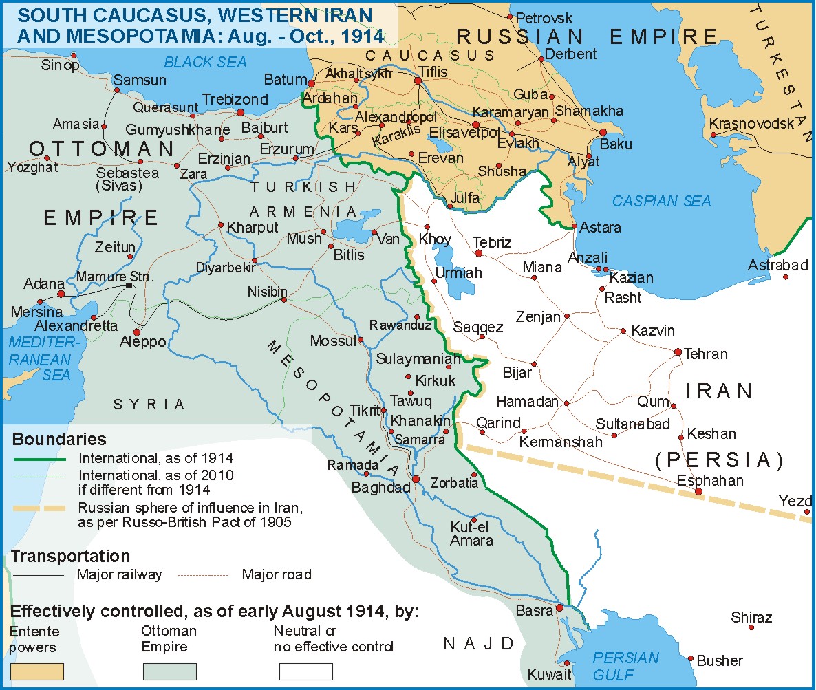
Theater of Operations
Before beginning the requisite examination of the operation, let us
briefly describe the theater of operations: it is 190 kilometers as the
crow flies from the village of Kucuk Makrıyalı ((today's Kemalpaşa))
on the Black Sea to Molla Osman mountain at the corner of the border.
From here it is another 150 kilometers to Little Arafat, where the
borders of Russia, Turkey and Iran meet, making the total distance for
the Turks 340 kilometers. So even if both armies had lines of
communications, the Turks’ lines were farther because the Russian
occupied Azerbaijan. When hostilities began the first encounter
occurred at this second-degree location. The borderline in the vast
and mountainous area had the following characteristics:
·
On the Turkish side, there are the Lazistan Mountains that extend
along the Black Sea coast to the south and east and which are bounded
by the Cürüksu ((today Çoruh)) valley. The northern section of the
range is thick forest and reaches up to Batumi and Artvin, with the
two sides of the Cürüksu Valley walled in by the Little Caucasus
Mountains. To the north of the Karasu and south of the Çürüksu
rivers a great many other branches of the range help to form the
Little Caucasus Mountains in the border area. South of this last
range there is the Aras River, south of which is the Murad River.
The peaks of Ermeni Mountain are separate from the main mountain
range. Starting from Kızlar Mountain and up to Ağrı Mountain, all
along the Russian border these peaks continue.
South of the Şeriulbesu and Yukarı Murad River valleys a separate
branch known as the Kurdistan Mountains extend north to south, east
of Lake Van, forming the border between Turkey and Iran.
On the Russian side, the Little Caucasus Mountains are quite irregular
and bordered by the Kur and Aras Rivers, along with the Kars and
Arpa streams. In the north, there is the large Riyan valley and the
Middle Kur, as well.
If we look carefully at the communications lines of the two antagonists
we see the following differences and specifics:
Between Russia and the Caucasus there are two lines Russia can avail
itself of:
The Rostov-Baku-Tiflis railroad
The Vladıkafkas-Georgia military road
Other than these two routes, and the ships of the Caspian Sea, Russia
has no other means for transporting its own forces. Because of the
effect of the Turkish Navy in the Black Sea, sea transport for the
Russians there is uncertain. The Novorossiysk-Poti route is quite
distant and because it must gather and transport reserve forces from
Russia and Siberia, Russia cannot dedicate the Caucasus
communications lines solely to Caucasus forces. The Caucasus army
corps detachments are not made up of people from the Caucasus.
The Moslems of this population and Georgians and Armenians who
have been excused from military service have been organized in
southern Russia and Stavropol.
In short, roads from Russia to the Caucasus and from the Caucasus
to Russia have been choked with reserves being transported back and
forth.
In addition, there is the south Caucasus railway; so it is possible for
Russia to quickly gather troops at Batumi, or at Kars or Sarıkamıs,
to where the railway was extended shortly before the war, or at
Yerevan or at the end point of the railway in this region in the
neighborhood of Tebriz.
These are the roads that go to the border from various locations of the
railway:
Along the coast from Batum to Atina (Pazar);
A road through the Cürüksu valley to Okum in the Suram area;
Another road passes through the Mihaılu and Kur valleys (Ahalçih-
Ardahan), crosses the border south of Oltu and terminates at
Hasankale.
Hasankale.
The transport lines between Anatolia and the Caucasus start at Kars
and, passing through Köprüköy and Hasankale, terminate at Erzurum.
There is also a rough road starting at Kars through Kağızman up to
Köprüköy. A mountain road goes from Kağızman to Karakilise; and
there are a few mountain roads from Serdarabad to the Diyadin-
Beyazid area. Another road starts at Şahtahtı and passes through
Iranian territory to Mako, ending up around Beyazid.

Map accompanying the article. The Black Sea is at upper left.
On the Russian side, there are just two roads between the
railway and the border: (1)
(1) Roads for the transport and delivery of troops.
One is from Gümrü to Ahalçih; the other goes from Serdarabad to
Artvin via Kars and Ardahan. Consequently, because of the dearth
of military roads it would be difficult to assemble and concentrate
forces for operations.
The Turks have no railway at all, with the Anatolian railway ending
east of Ankara. Most of the roads are poor, making it nearly
impossible for field cannons and vehicles to pass. Nevertheless,
from the standpoint of military strategy, the placement and
condition of these roads is not actually that bad.
The main road runs as follows: Trabzon – Erzurum – Hasankale –
Köprüköy – Karakilise – Diyadin – Beyazid, almost to the border.
The Erzurum – Beyazid road is quite close to the border after
Köprüköy but because it is vulnerable to threats it is possible to
instead take the Erzurum – Malazgirt – Van road.
In addition to the Trabzon – Erzurum road, there are the Rize –
Erzurum and Rize – Oğdum – Erzurum roads near the border.
Consequently, there are enough military roads and reserves can
be quickly placed at various locations for war.
The necessary roads for reaching the border and the Caucasus
Railway have been outlined above.
//End of Part I//
Hiç yorum yok:
Yorum Gönder