
between İmadiye and Çölemerik (Hakkari), as he
proceeds towards Van.//

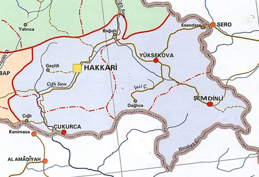
This second-section map included with the travel
log shows the route taken from İmadiye, lower left,
to Çölemerik (Hakkari), upper right.
İmadiye - Çölemerik (Hakkari)
Upon leaving İmadiye, following a pass for 3 hours one passes through
1,800-meter-altitude hills and, subsequently, through a great hollowed-
out rock, probably from the days when humans first lived. After that,
one passes two streams that empty into the Şapur River and reaches
two Yezidi villages called Hayzi and Merak Hacı. Both villages are on
the banks of two streams that flow from the Torargarga ridges.
Payas's house is up on a ridge, next to a church which has been built
in a depression there. Our caravan spent the night in the square in front
of this house. A bit further on one finds Şey Moylar village, which is
southeast of Duri village and where there are active Jewish religious
institutions!
After following a bank of the Zab River from here for a while, we
crossed over to the other bank, where Zeri village is situated. There
are important Christian religious institutions in this village. From Zeri
there are two roads to Çölemerik, one of which follows the left bank
north to Çal, where Kurds live. Large caravans cannot pass along this
road because the one bridge over the Zab River was destroyed by a
flood. The other road from Zeri goes north to a Nestorian village and
joins the Zab above the village of Lizan.
The Zab River's other name is "Çığlı Suyu".
Caravans take this road along a steep and stoney ridge and descend
into the Zab valley up to a forested valley, where Lizan is located. Here,
like all the rest of the places around here, all the Zab River bridges are
wooden and sway as one crosses over. Sometimes it takes hours to get
animals across the bridge. On the other side of the river, at a height of
hundreds of meters, Gargarı Mountain, with its sharp cliffs, rises and
there are two poor villages situated in the middle of its ridges.
From here the road heads north through the rocky valley of the Zab and
for many hours there is no straight path forward. Many times we had to
unload the animals' burdens and carry them on our backs through these
inopportune areas. At a place here called Sala Bey Han there are houses
on all sides of the narrow valleys, where tobacco and rice are raised,
and some fruit trees can be seen, as well.
At Mülk Balmu village the valley begins to widen and travel is not
so difficult after that. This village is 15 kilometers from Lizan and it
took 8 hours to get here. Travelers spend the night in the home of
the village chief, who is called Mülk ruler. And although there is no
decent place to pitch a tent and it is recommended that one stay in
Mülk's house and under his protection, you still have to give him a
generous tip.
![Assyrians [Nestorians]](http://www.atour.com/media/images/news/aahgn/assyrian/20120617a-NASTUR%C4%B0LER-Nestorians/1.jpg)
The men of Sala Bey Han are ill-mannered and ill-clothed and they
are forever having minor clashes with the Kurds who live to the south.
Their houses are on the rocky slopes and are built like balconies. In
fact, it would be impossible to build any other kind of house on these
rocky precipices. These Nestorians are all tall and well-built men but
they lack manners. They wear their hair long, in two braids, which
sway back and forth on either side. On their heads they wear a
conical cap, a colorful short jacket on their backs and sandals on
their feet. The number of them who can read and write is quite small.
The children who go to the schools that the English missionaries have
opened are learning to read and write. The Nestorians go from village
to village on foot but sometimes they use mules and donkeys.
Nevertheless, for the most part, they transport provisions and other
things on their backs. Very rarely, merchants from İmadiye and
Çölemerik come here.
A few kilometers after Mülk Balmu village, one comes to Berbacayi
village. Turning north and then east, and following a cultivated valley,
the villages of Cuma, Mezra and Gondikta are encountered. The tall
and centuries-old walnut trees of this elegant valley are most pleasant
to see and the gardens are a feast for the eyes. The road next to the
old church in Gondikta village turns north, with Valtu Mountain on
the right, and follows the steep and sharp watershed line of Karadağ
Mountain. Along the way, one see a few village houses.
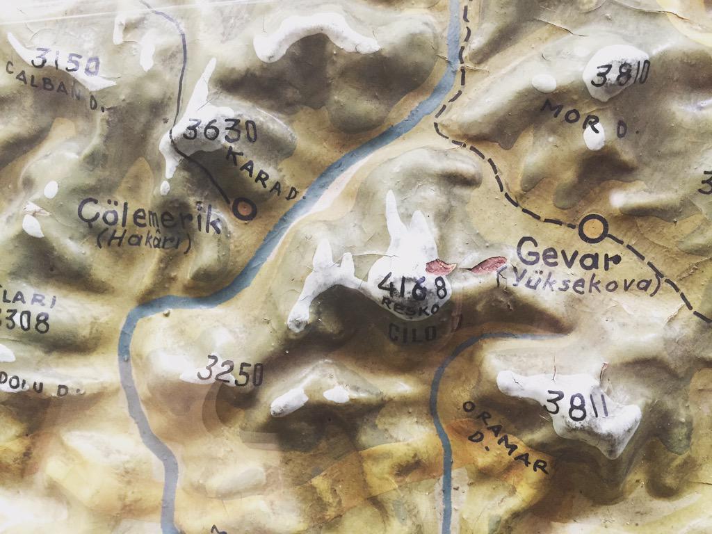
The highest, snow-covered peak of Karadağ is at an altitude of
2,600 meters. Further on, central Kurdistan's Celu Mountains come
into view, with some of these peaks rising to 4,000 meters. Harekita
Mountain looms threateningly over the spiked hills of the Kokobulak
Pass to the north. From here the deep and vast valleys of the Zab can
be seen and to the south one sees the snow-covered Valtu Mountain.
One then reaches Rayat village, which is 20 kilometers from Çölemerik.
The village sits on the bank of a stream by the same name. The Rayat
valley, which is to the northeast of the Zab River, is steep and stoney,
making transportation difficult. There is a church and a few houses on
the near side of Rayat. After a few kilometers, the Rayat valley widens
and narrows again before joining with the Zab valley, with the two
waters uniting with each other there.
From here, one follows the right bank of the Zab River. In some
places movement becomes so difficult that the animals' loads have to
be taken off them. The Zab River passes by places where the Orivuku
streams' water flow into it on the right. Then, crossing over the water
on a wooden bridge that sways like a swing, one reaches Çölemerik,
most of whose population are Kurds. Like others elsewhere, the
populace head for the high pastures in summer. There is a district
chief and a number of Gendarmerie troops here, as well as a telegraph
line to Van.
//END of PART II//
Hiç yorum yok:
Yorum Gönder